San Felipe Springs, located in Val
Verde county on the outskirts of Del Rio, are the fourth
largest in Texas. There are a group of ten or more
springs that extend for over a mile along San Felipe
Creek on the grounds of the San Felipe Country Club and on several ranches to the north. A groundwater divide near Brackettville separates
this portion of the Edwards Aquifer from the central
portion and the larger springs in San Marcos and New
Braunfels. In 1849, Captain S. G. French described San Felipe Springs and correctly
noted they are the most western of a whole series of
outflows from the Edwards. He wrote:
To the north of the
road, and half mile distant, there is a beautiful
spring of water, fifty feet in diameter at the
surface, the sides of which incline towards a centre,
like an inverted cone, and then, sinking in a
cylindrical form to a depth of twenty-eight feet,
through a soil of hard clay, afford a passage for the
water to rise. The water comes to the surface with a
slight ebullition, and flows off in a volume that
would fill a cylinder two feet in diameter. This
spring is the source of the San Felipe; as it flows
on, the volume of its water is increased by other
large springs, on either side; until it becomes a
creek, when it empties into the Rio Grande, eight
miles below the crossing, some thirty feet wide and
several feet deep. Near its junction with the Rio
Grande, its banks are shaded with large groves of
pecan, maple, elm, and mulberry trees.
Other early explorers described seven deep,
clear pools at San Felipe Springs, with many large fish,
surrounded by hackberry trees, grapevines, and cattails. Gaspar Castano de Sosa may have been the first European to visit in
1590. By the late 17th century many other Spanish explorers and
settlers became familiar with the Springs, since the the Kings
Highway to San Antonio and El Paso passed right by. Between 1672 and 1783 several attempts by the Spanish government of New Spain to establish settlements in the area were not successful. By the mid 1800s, mounted cavalry units and stagecoaches made great use
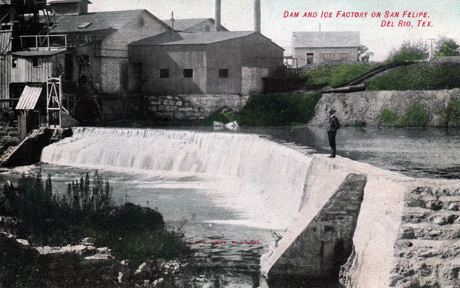
of the Springs. The first permanent settlement was established in 1862 by James and Paula Taylor, and development along the Creek was rapid. Irrigation canals and dams were built to
water vineyards, orchards, and gardens, and spring water was hauled and sold in town until 1900
when a water system was installed. In 1882 two gristmills were
using the water for power, and by 1901 there was also an electric
light and ice plant (Brune, 1981 and San Felipe Creek Commissioners, 2007).
The westernmost of the line of fault springs
are the San Felipe springs near Del Rio. They break out at the edge of
the Edwards Plateau, 2 miles northeast of Del Rio and about 5 miles from the
Rio Grande. The pool is almost as large as that at the head of the San
Antonio River. From the deep-seated rock at its bottom the water
can be seen welling up in a great column, and has the same peculiar
greenish-blue color as that of the other streams of this class. No
trees surround it; it is alone - a fountain in the desert. The rocks
from which it bursts - the Fort Worth limestones - have the same kind of
joints and faults as are found at San Antonio and Austin. The outflow
from the pool forms a bold, rushing stream that runs off to the Rio Grande,
some 5 miles distant. The spring stream, in addition to running a mill
and supplying the village with water, is partially utilized to supply 15
miles of irrigation ditch and to irrigate 5,000 acres, and can furnish water
for the irrigation of several thousand acres more. Mr. Babb's
measurements make a total discharge of 19 second-feet, or about 12,000,000
gallons per day.
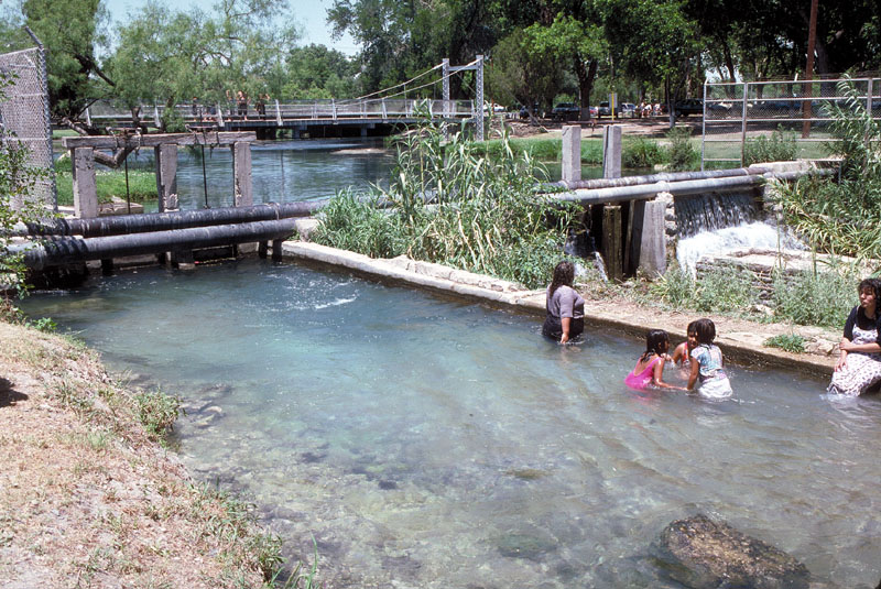
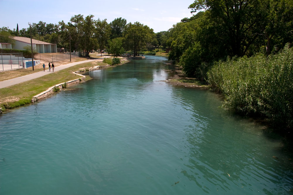
San Felipe Springs still supply the city of
Del Rio and Laughlin Air Force Base. Although much of the area downstream from the Springs is now urban, about 3,000 acre-feet per year are still delivered via the irrigation canals and used for agriculture. Swimming holes at Horseshoe
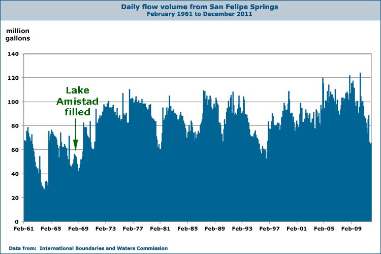
Park and Lions Park are very popular cooling-off spots. For a discussion of whether the filling of Lake Admistad has increased flows at San Felipe Springs, see the Goodenough Spring page.
In January 2004, scientists announced the
discovery of a new species of fish in San Felipe Creek, the first new fish
discovered in Texas in over 30 years. The San Felipe gambusia was first
noticed in 1997 by Gary Garrett, a research biologist for the Texas Parks and
Wildlife Department. He asked biology professor Robert Edwards to help him
identify it, and the two spent years reviewing existing collections before
writing a scientific paper documenting the discovery. They gave it the
scientific name of Gambusia clarkshubbi to honor renowned UT Austin fish
expert Clark Hubbs. Garrett and Edwards said the fish had probably been in
the Creek for many years, but by 1997 it had became easier to find because its
numbers increased due to efforts by the city of Del Rio and the San Felipe
Country Club to improve the Creek's habitat.
In 2007 the San Felipe Creek Commissioners completed a Master Plan that calls for a balance between recreation, development, and preservation of the natural beauty. Click on the link or image to download.
In 2014, a major new study was completed to determine correlations and potential impacts of groundwater pumping in local springflows, lake elevations, and groundwater levels. The study found that, in general, pumping decreases springflow.
This area is not covered by a groundwater district to manage pumping. Jerry Simpton, who serves as vice-chair of the Texas Water Development Board Region J Water Planning Group, said “I’m very, very pleased with the results of the study. They were able to take 45 years of data, a lot of it from the International Boundary and Water Commission on well elevations, and compare that to springflow, lake elevation, rainfall and develop a model that most groundwater conservation districts never have and sure don’t have during the first years of their operation. So if we decide to form a groundwater district, we now have the basic tool that any district needs to make decisions about rules and thresholds to cut back."
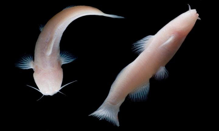
On June 17, Christine S. Sinatra reported news from the College of Natural Sciences at the University of Texas at Austin: the university's curator of ichthyology Dean Hendrickson had identified two live fish collected in a deep limestone cave near Del Rio as Prietella phreatophila, the rare Mexican blindcat. The fish grows to only about three inches in length and is adapted to a unique ecological niche where things like eyes, pigmentation for camouflage, and speed are not needed. Instead it has evolved extra-sensory abilities to survive in total darkness. It is slow-moving and a pale pink color because its blood can be seen through translucent skin.
The discovery brought to three the number of blind catfish species known in the United States. The other two are the Toothless blindcat (Trogloglanis pattersoni) and the Widemouth blindcat (Satan eurystomus), both found only in wells more than 1,000 feet deep underneath San Antonio (see the discussion of Deep Water Biota on the Intro page).
There had been rumors of sightings of blind, white catfish since the 1960s in the area of Amistad National Recreation Area, but none had ever been confirmed or scientifically identified. Jack Johnson, a National Park Service resource manager at Amistad, spotted some of fish in April of 2015 and assembled a team of biologists that succeeded in netting two specimens where groundwater rose to fill a deep cave. They were removed to the San Antonio Zoo where they will be maintained alive in a facility specially designed for cave and aquifer species.
The discovery lends support to the theory that water-filled caves below the Rio Grande connect the Texas and Mexico portions of the Edwards-Trinity Aquifer.
Others involved in the discovery were Andy Gluesenkamp and Ben Hutchins of the Texas Parks and Wildlife Department, Gary Garrett and Adam Cohen of UT Austin, and Jean Krejca of Zara Environmental.
Mexican blindcats found in a limestone cave near Del Rio. Photo by Dante Fenolio.
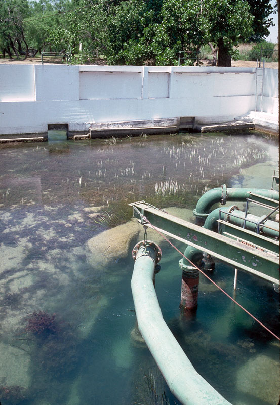
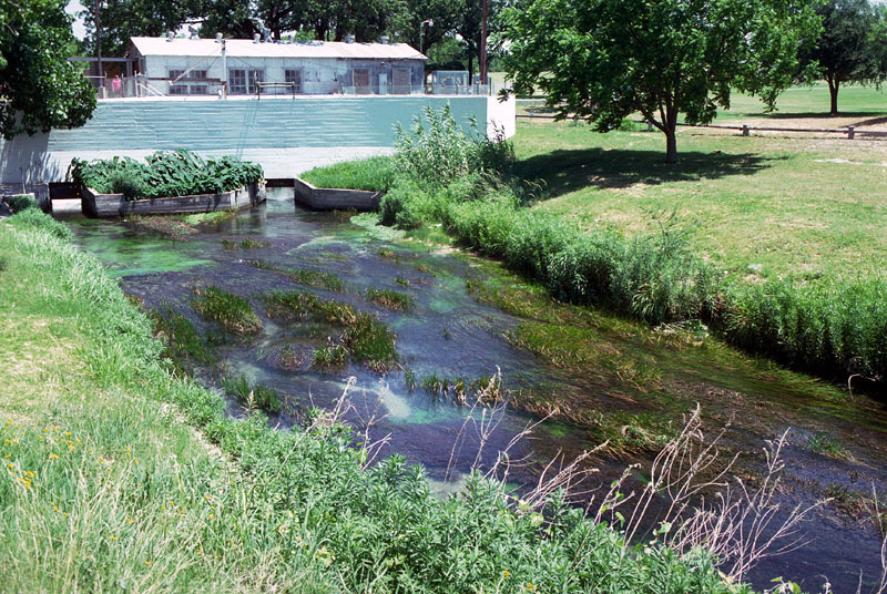
This is Spring #3 in the graphic above. Water bubbles up from the depths
and runs out of this chamber, filling the swimming hole in Horseshoe Park.
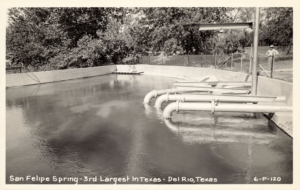
The massive pipes sticking into the Springs extract water for municipal supply. Spring #3 and Spring #2 just to the east are the only water source for the city of Del Rio and Laughlin AFB. Because of homeland security concerns, one can no longer just walk up and take pictures. I took this photo and the one below in the mid 1980s.
When I took the photo above in the mid 1980s, the water supply infrastructure looked pretty much the same as decades earlier when this Real Photo postcard was made.
Photo taken from the other side of the wall in the photo above, showing
the discharge of Spring #3 toward the swimming hole, minus what is being taken for municipal use.
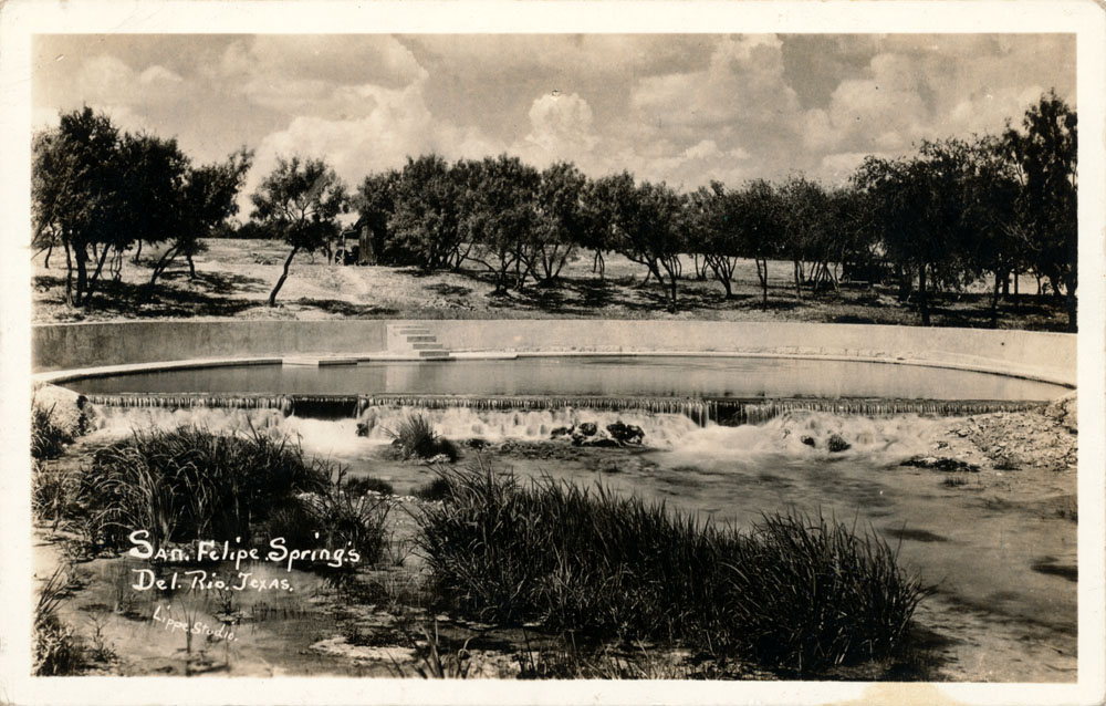
A very rare Real Photo postcard of Spring #2 before the municipal water supply pumphouse was added.
Real Photo postcards were introduced in 1906 by Eastman Kodak and made it possible for anyone to have a postcard made using their own photograph. As such, they were usually produced in very limited numbers. The style of the back of the card dates it to pre-1907.
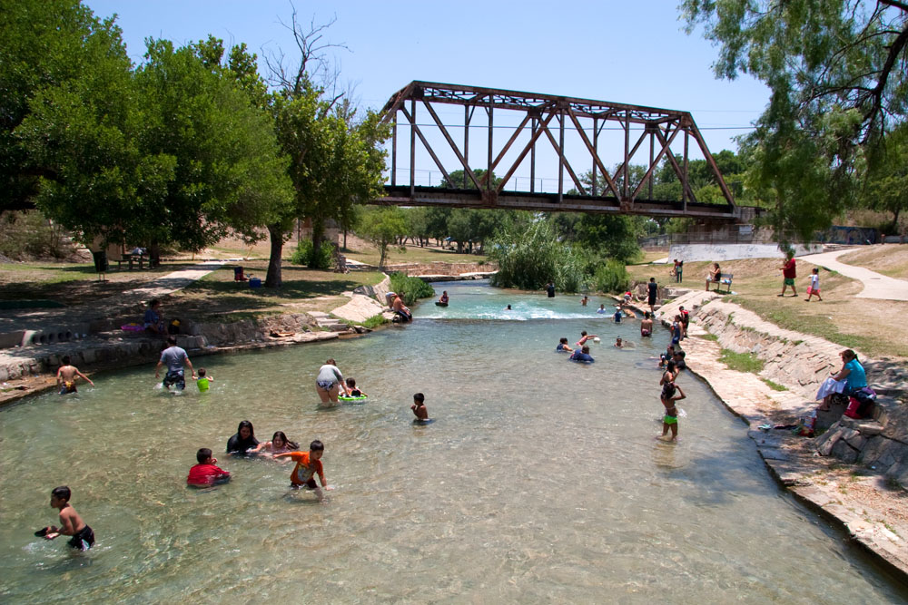
The situation is exactly the same more than two decades later - when the summer sun blazes in the dry Del Rio sky, this is still a very popular cooling-off place.
From the opposite bank and looking in the opposite direction from the
photo above. Notice Highway 90 suspended over the swimming hole in the
background.
Water leaving Blue Lake, which is fed by Springs 1, 2, and 4. Notice how
discharge from the Lake is split. Water flowing to San Felipe Creek is
running over the spillway on the right, and the Acequia Madre Canal is on
the left.
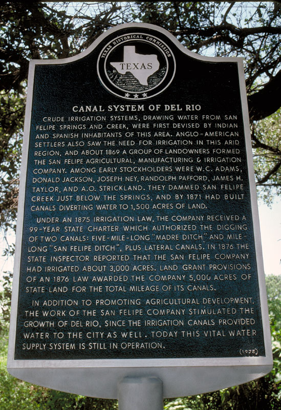
Crude irrigation systems,
drawing water from San Felipe Springs and Creek, were first devised by
Indian and Spanish inhabitants of this area. Anglo-American settlers also
saw the need for irrigation in this arid region, and about 1869 a group of
landowners formed the San Felipe Agricultural, Manufacturing & Irrigation
Company. Among early stockholders were W. C. Adams, Donald Jackson, Joseph
Ney, Randolph Pafford, James H. Taylor, and A. O. Strickland. They dammed
San Felipe Creek just below the Springs, and by 1871 had built canals
diverting water to 1,500 acres of land.
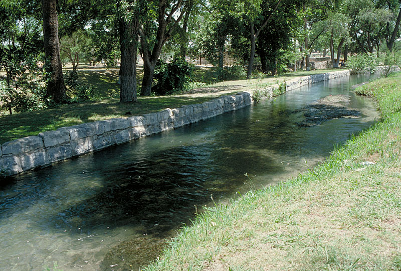
Under an 1875 irrigation law, the company received a 99-year state charter which authorized the digging of two canals: five mile long "Madre Ditch", and mile-long "San Felipe Ditch", plus lateral canals. In 1876 the state inspector reported that the San Felipe Company had irrigated about 3,000 acres. Land grant provisions of an 1876 law awarded the Company 5,000 acres of state land for the total mileage of its canals.
In addition to promoting agricultural development, the work of the San Felipe Company stimulated the growth of Del Rio, since the irrigation canals provided water to the city as well. Today this vital water supply system is still in operation.
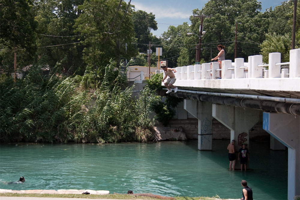
One time my mother asked me what I would do if my friend Tommy jumped off a bridge. If I had lived in Del Rio, my answer might have been "I'm going first!" Jumping off the Gillis Avenue bridge is a popular pastime here. Who am I to judge.
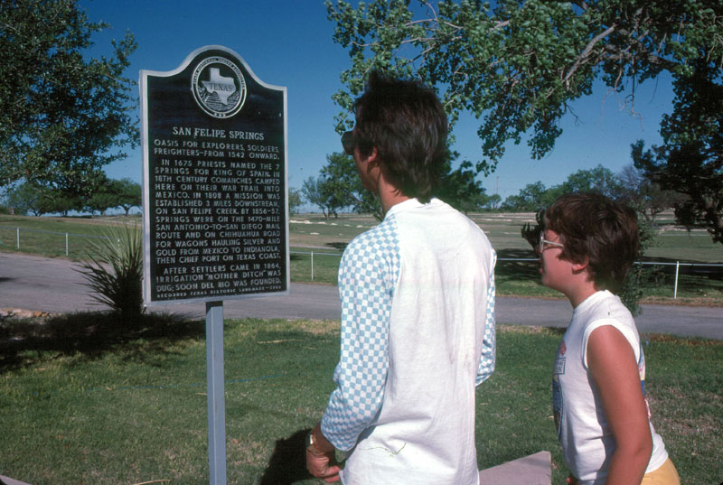
Oasis for explorers,
soldiers, freighters - from 1542 onward.
In 1675 priests named the 7
springs for King of Spain. In 18th century Comanches camped here on
their war trail into Mexico. In 1808 a mission was established 3
miles downstream, on San Felipe Creek. By 1856-57 springs were on
the 1470-mile San Antonio-to-San Diego mail route and on Chihuahua Road
for wagons hauling silver and gold from Mexico to Indianola, then chief
port on Texas coast.
After settlers came in 1864,
irrigation "Mother Ditch" was dug: soon Del Rio was founded.