|
|
The J-17 Index Well Recent J-17 index well readings are available from the San Antonio Water System.
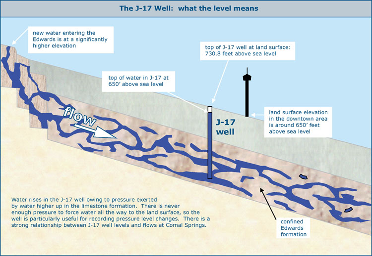
The figure below illustrates this concept...the Edwards formation is between 300 and 700 feet thick, so it is about as thick as the Tower of the Americas is tall. Out to the west in the recharge zone, the Edwards outcrop at the land surface is higher than the top of the Tower. Water tends to flow downhill, and it so happens that "downhill" is directly under most of San Antonio. Now water is heavy stuff, and as new water enters the formation in the recharge zone, it places tremendous pressure on water already deep inside, forcing water up through cracks and wells toward the land surface. So water rises in the test well because of pressure being exerted by water higher up in the Edwards formation out to the west. It does not rise all the way to the elevation of water to the west because of friction. When water does rises all the way to the top of a well in this manner, the well is called artesian and water flows out without pumping. A good index well such as J-17 is one in which pressure is never sufficient to cause the well to become artesian. To get water out of J-17, it would have to be pumped. The land surface at the top of the J-17 well is at 730.8 feet above sea level, and the downtown area around the Tower of the Americas is around 650 feet above sea level. A reported Aquifer level of 650 feet, for example, would indicate the top of water in the well is about even with the bottom of the Tower. The water in the well is still 80.8 feet below the land surface, so to extract water from the well it would have to be pumped that distance. It is still another 400 feet from 650 to the top of the Edwards limestone formation.
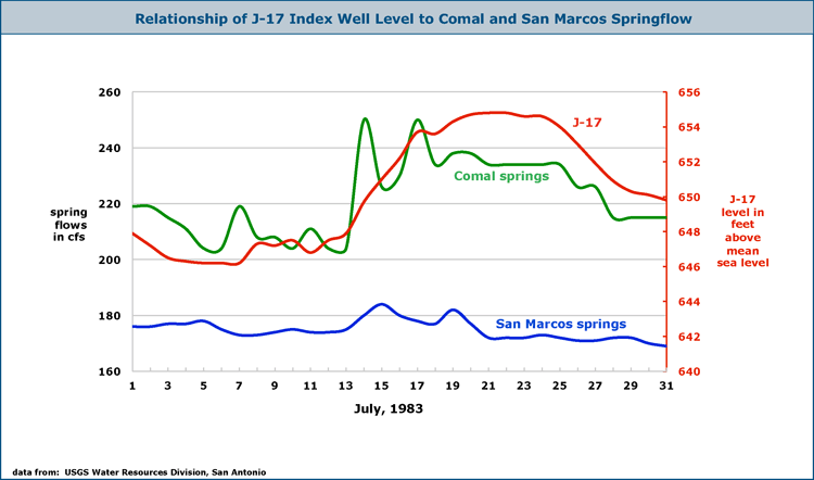
The graph below illustrates the relationship between J-17 levels and springflows. There is a good relationship between the level of the J-17 well and flows at Comal Springs. What happened in July of 1983 is typical - when the J-17 level increased by about six feet, there was an obvious increase in flows at Comal Springs. Most of the water that becomes Comal springflow originates with recharge far to the west of the Springs and moves past the J-17 well on its way toward New Braunfels. In contrast, much of the water discharging at San Marcos Springs originates from recharge in the vicinity of the Springs and does not move past the J-17 well (see Flowpath Map). This is why the relationship between the J-17 well and San Marcos Springs is not as pronounced. We should note that on the graphs below, the y-axes do not start at zero, so the reader should be aware the areas under the curves are exaggerated and are not proportional to actual changes in the numbers which the curves represent. In other words, these graphs are a lie, because a truthful chart will always have axes that starts at zero. People use the axis trick all the time to make their graphs tell the story they want. It is sometimes useful to look at data that way, but it is always a lie. The only way to mitigate the lie is to disclose that you have done it, that's why I'm telling you this.
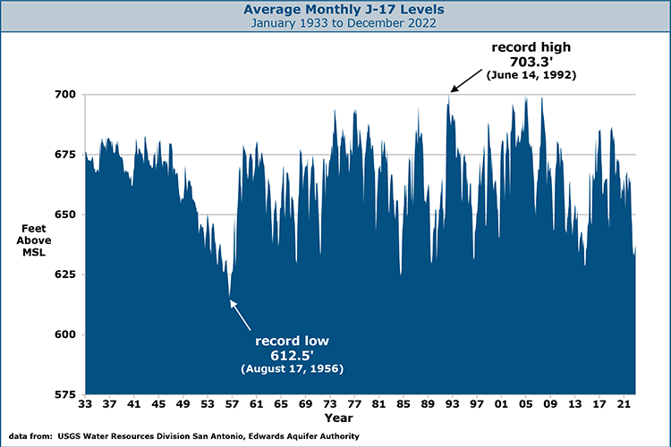
Flows at Comal Springs become intermittent when the level of the J-17 monitoring well drops below 620 feet. All flow at Comal ceases at an elevation of 618 feet. During the '50s drought, the Springs were dry from June to November of 1956. In a repeat of the 1950's drought, Comal Springs would be dry for a number of years. History does not record a time when the San Marcos Springs have ceased to flow. The lowest recorded flow rate was 46 cubic feet per second in August of 1956. San Marcos Springs would cease to flow with a water elevation of about 574 feet at the Springs. The chart below shows average monthly J-17 levels since January 1933. Droughts in 1966, 1970, 1984, 1988, 1996, 2006, and 2009 are apparent in J-17 levels. It's a little hard to see here, but in many years the J-17 level recovers quickly around October....these rapid rises correspond to declines in use at the end of summer and soaking rainfalls associated with tropical storms and hurricanes. In Texas, climatologists use October as the beginning of the "water year", a division based on a general pattern of annual wet and dry periods rather than a calendar year.
How did the J-17 get its name? The J-17 designation was an early, almost random name and we still call it J-17 simply because that is the name that stuck in the public mind. The real name of the well is AY-68-37-203. That's the short answer, faithful readers of these pages know I usually also have a long answer: Until the early 1970's, the general public did not know the well by any name at all, and it wasn't even always the well used for reporting water levels. The newspaper and media would just typically mention "a well near Fort Sam Houston" or "a monitoring well at San Antonio". In some cases they were talking about J-17, but in many cases they were talking about another nearby well at the Beverly Lodges Tourist Court, where continuous water level monitoring had started in 1932. In fact, most of the early data for J-17 actually came from the Beverly Lodges well. Continuous monitoring at J-17 did not start until about 1960, and people noticed there was a real good correlation between the two wells, so eventually the Beverly Lodges readings were used to estimate J-17 levels back to 1932. In those early days, there was a lot of confusion about well names. They might be named after the current property owner or the one that originally drilled it. Or, they might be assigned a name using one of several different well numbering systems that were used in Texas beginning in the 1930s. One of those systems involved simply assigning a number as you went back and forth horizontally across the map. Another involved dividing an area into a lettered grid, then smaller subdivisions with numbers, then a number to indicate the well, so that a well might end up with a designation such as C-2-5. The last digit usually came from the order in which the well was inventoried, which was most often simply the order you'd get to them as you were driving down the road. Sometimes these systems were used more than once for wells in the same area. For example, in dozens of official reports and studies the Beverly Lodges well was either called well number 436 or well number 26, and it was also known as the Ed. Steves & Sons well. We only know this because one study listed other names the same well was known by. In one of these numbering systems, the part of Bexar county where J-17 is located was lettered J and it was the 17th well they happened to give a number to. It then became commonly identified in reports and studies as J-17. Then in about 1973 the media started consistently referring to J-17 in reporting well levels. The public got to know it that way and we still call it that because everyone knows what is. All of the different numbering systems that were used caused a great deal of confusion because the well name was not necessarily unique. You could end up with several wells in different counties with the same identifier, and it was hard to compare one report with another because well names were not always the same. So the state finally implemented a numbering system based on geography, such that every well could have a unique identifier. The figure below shows how it works.
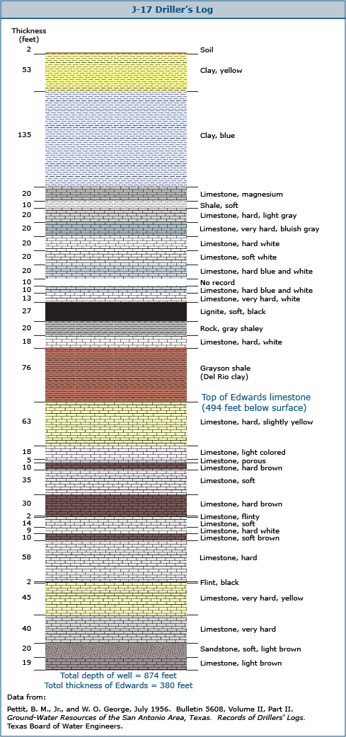
J-17 Driller's Log Here is a graphic I prepared using driller's log data for the J-17. At this location, the top of the Edwards limestone occurs at 494 feet below the surface, and from there the Edwards is 380 feet thick. The total depth of the well is 874 feet.
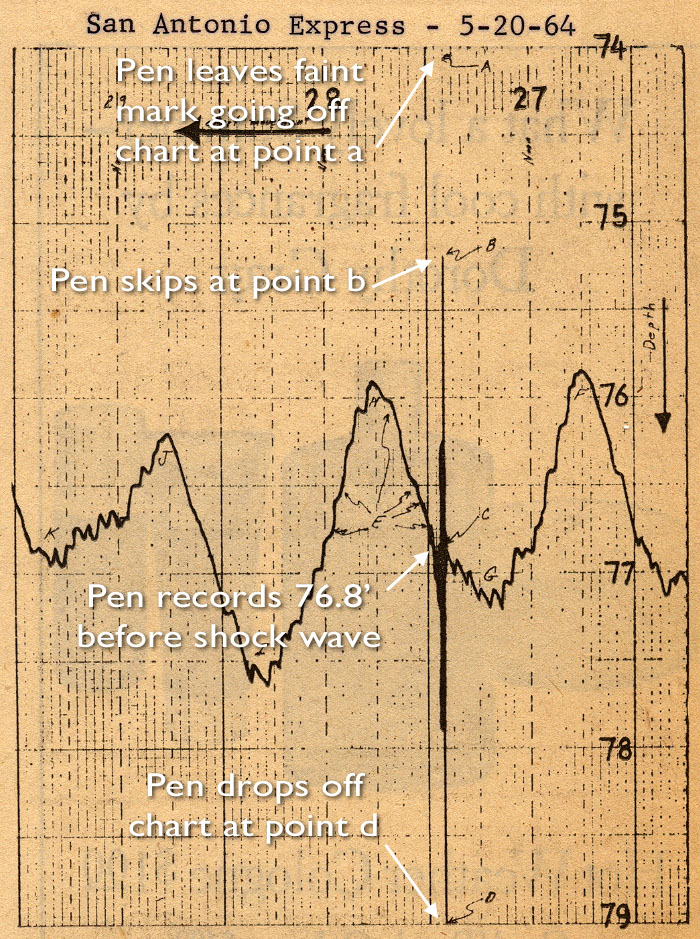
The Good Friday Earthquake at J-17
|